
Map · Bali
Bali on one map
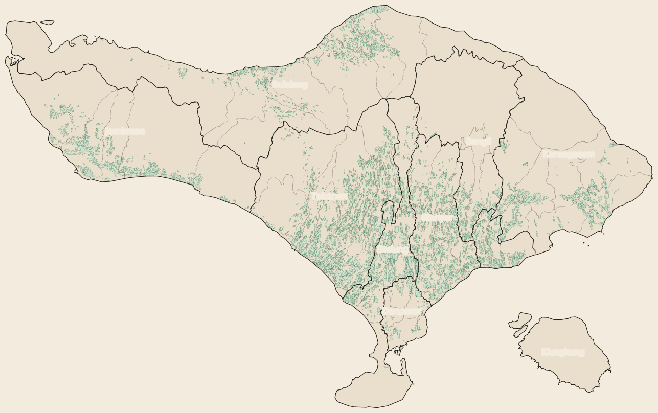
Every kabupaten, kecamatan and desa of the province, the protected rice fields and an indicative coastal strip, with the figures for each area.
This map helps you find where a plot lies before you ask the right office about it: its desa, kecamatan and kabupaten, whether it is near the protected rice fields, and whether it is close to the coast. Paste the plot's coordinates or a Google Maps link to see where it falls. It is not a land register and not a zoning map. The legal source for what may be built on a plot is the detailed spatial plan (RDTR) of the kabupaten, read with a notary/PPAT.
Kabupaten and kota in figures
| Kabupaten or kota | Area, ha | Protected rice fields, ha | Share |
|---|---|---|---|
| Kabupaten Jembrana | 85,271 | 7,029 | 8.2% |
| Kabupaten Tabanan | 85,288 | 19,439 | 22.8% |
| Kabupaten Badung | 40,042 | 8,633 | 21.6% |
| Kabupaten Gianyar | 36,589 | 10,558 | 28.9% |
| Kabupaten Klungkung | 31,527 | 3,426 | 10.9% |
| Kabupaten Bangli | 52,898 | 2,196 | 4.2% |
| Kabupaten Karangasem | 84,285 | 6,455 | 7.7% |
| Kabupaten Buleleng | 132,826 | 8,616 | 6.5% |
| Kota Denpasar | 12,640 | 1,611 | 12.8% |
| Province of Bali | 561,366 | 67,963 | 12.1% |
- Kabupaten Jembrana
- Area, ha
- 85,271
- Protected rice fields, ha
- 7,029
- Share
- 8.2%
- Kabupaten Tabanan
- Area, ha
- 85,288
- Protected rice fields, ha
- 19,439
- Share
- 22.8%
- Kabupaten Badung
- Area, ha
- 40,042
- Protected rice fields, ha
- 8,633
- Share
- 21.6%
- Kabupaten Gianyar
- Area, ha
- 36,589
- Protected rice fields, ha
- 10,558
- Share
- 28.9%
- Kabupaten Klungkung
- Area, ha
- 31,527
- Protected rice fields, ha
- 3,426
- Share
- 10.9%
- Kabupaten Bangli
- Area, ha
- 52,898
- Protected rice fields, ha
- 2,196
- Share
- 4.2%
- Kabupaten Karangasem
- Area, ha
- 84,285
- Protected rice fields, ha
- 6,455
- Share
- 7.7%
- Kabupaten Buleleng
- Area, ha
- 132,826
- Protected rice fields, ha
- 8,616
- Share
- 6.5%
- Kota Denpasar
- Area, ha
- 12,640
- Protected rice fields, ha
- 1,611
- Share
- 12.8%
- Province of Bali
- Area, ha
- 561,366
- Protected rice fields, ha
- 67,963
- Share
- 12.1%
Public offices by kabupaten and kota
The public offices a buyer or builder deals with in each kabupaten and kota, with the address each office publishes. Opening hours and addresses change: check the office's site or call before you go.
Province of Bali
- Land office (BPN)ATR/BPN land administration. The kabupaten and kota land offices issue certificates and register land rights.Kantor Wilayah BPN Provinsi Bali (opens in a new tab)Jl. Cok Agung Tresna No. 7, DenpasarSource, checked 1 October 2026 (opens in a new tab)
- Licensing office (DPMPTSP)Business licences through OSS and help with permit applications.Dinas Penanaman Modal dan Pelayanan Terpadu Satu Pintu Provinsi Bali (opens in a new tab)Jl. Raya Puputan Niti Mandala Renon, Denpasar-BaliSource, checked 1 October 2026 (opens in a new tab)
- Majelis Desa AdatThe council of the customary villages (desa adat) for this area.Majelis Desa Adat Provinsi BaliJalan Cok Agung Tresna, Renon, DenpasarSource, checked 1 October 2026 (opens in a new tab)
Kabupaten Jembrana
- Land office (BPN)ATR/BPN land administration. The kabupaten and kota land offices issue certificates and register land rights.Kantor Pertanahan Kabupaten Jembrana (opens in a new tab)Jalan Mayor Sugianyar No.9, Pendem, Kec. Negara, Kabupaten JembranaSource, checked 1 October 2026 (opens in a new tab)
- Licensing office (DPMPTSP)Business licences through OSS and help with permit applications.Dinas Penanaman Modal dan Pelayanan Terpadu Satu Pintu (opens in a new tab)Source, checked 1 October 2026 (opens in a new tab)
- Building approval (PBG and SLF)Technical review of the building approval and the certificate of fitness for use, through SIMBG.Dinas Pekerjaan Umum, Penataan Ruang, dan Perhubungan (opens in a new tab)Source, checked 1 October 2026 (opens in a new tab)
- Majelis Desa AdatThe council of the customary villages (desa adat) for this area.Majelis Desa Adat Kabupaten JembranaSource, checked 1 October 2026 (opens in a new tab)
- Public service mall (MPP)One building with counters of several offices. Check which counters it has before you go.Mal Pelayanan Publik Kabupaten Jembrana (opens in a new tab)Jl. Udayana No.16 Keluranan Baler Bale Agung, Kec. Negara, Kab. Jembrana, Prov. BaliCounters confirmed here: Land office (BPN), Licensing office (DPMPTSP), Building approval (PBG and SLF). There may be others.Phone: (0365) 4740120Source, checked 2 October 2026 (opens in a new tab)
Kabupaten Tabanan
- Land office (BPN)ATR/BPN land administration. The kabupaten and kota land offices issue certificates and register land rights.Kantor Pertanahan Kabupaten Tabanan (opens in a new tab)Jalan Pulau Seribu No.16 Dauh Peken, Tabanan, BaliSource, checked 1 October 2026 (opens in a new tab)
- Licensing office (DPMPTSP)Business licences through OSS and help with permit applications.Dinas Penanaman Modal dan Pelayanan Perijinan Terpadu Satu Pintu (opens in a new tab)Jl. Rama nomor 1, Ds. Delod Peken, Kec. Tabanan, Kabupaten Tabanan, Bali 82121Source, checked 1 October 2026 (opens in a new tab)
- Building approval (PBG and SLF)Technical review of the building approval and the certificate of fitness for use, through SIMBG.Dinas Pekerjaan Umum dan Penataan Ruang (opens in a new tab)Jalan Arjuna No.2 Kabupaten TabananSource, checked 1 October 2026 (opens in a new tab)
- Majelis Desa AdatThe council of the customary villages (desa adat) for this area.Majelis Desa Adat Kabupaten TabananSource, checked 1 October 2026 (opens in a new tab)
- Public service mall (MPP)One building with counters of several offices. Check which counters it has before you go.Mal Pelayanan Publik Kabupaten TabananSource, checked 2 October 2026 (opens in a new tab)
Kabupaten Badung
- Land office (BPN)ATR/BPN land administration. The kabupaten and kota land offices issue certificates and register land rights.Kantor Pertanahan Kabupaten Badung (opens in a new tab)Jl. Dewi Saraswati No.3, Seminyak, Kec. Kuta, Kabupaten BadungSource, checked 1 October 2026 (opens in a new tab)
- Licensing office (DPMPTSP)Business licences through OSS and help with permit applications.Dinas Penanaman Modal dan Pelayanan Terpadu Satu Pintu Kabupaten Badung (opens in a new tab)Pusat Pemerintah, Sempidi, Kec. Mengwi, Kabupaten Badung, Bali 80351Phone: (0361) 471 525 9Source, checked 1 October 2026 (opens in a new tab)
- Building approval (PBG and SLF)Technical review of the building approval and the certificate of fitness for use, through SIMBG.Dinas Pekerjaan Umum dan Penataan Ruang Kabupaten Badung (opens in a new tab)Jl. Raya Lukluk - Sempidi, Pusat Pemerintahan Kabupaten Badung, Bali 80351Phone: 0361 9009401Source, checked 1 October 2026 (opens in a new tab)
- Majelis Desa AdatThe council of the customary villages (desa adat) for this area.Majelis Desa Adat Kabupaten BadungJalan Gunung Saru, Babakan Kerobokan Kaja, Kecamatan Kuta Utara, Kabupaten BadungSource, checked 1 October 2026 (opens in a new tab)
- Public service mall (MPP)One building with counters of several offices. Check which counters it has before you go.Mal Pelayanan Publik Kabupaten Badung (opens in a new tab)Pusat Pemerintahan Kab. Badung (Mangupraja Mandala)Counters confirmed here: Land office (BPN), Licensing office (DPMPTSP). There may be others.Source, checked 2 October 2026 (opens in a new tab)
Kabupaten Gianyar
- Land office (BPN)ATR/BPN land administration. The kabupaten and kota land offices issue certificates and register land rights.Kantor Pertanahan Kabupaten Gianyar (opens in a new tab)Jl. Astina Sel. No.3, Abianbase, Kec. Gianyar, Kabupaten Gianyar, Bali 80515Source, checked 1 October 2026 (opens in a new tab)
- Licensing office (DPMPTSP)Business licences through OSS and help with permit applications.Dinas Penanaman Modal dan Pelayanan Terpadu Satu Pintu Kabupaten Gianyar (opens in a new tab)Jl. Raya Buruan, Buruan, Kec. Blahbatuh, Kabupaten Gianyar, Bali 80581Phone: (0361) 2017300Source, checked 1 October 2026 (opens in a new tab)
- Building approval (PBG and SLF)Technical review of the building approval and the certificate of fitness for use, through SIMBG.Dinas Pekerjaan Umum dan Penataan Ruang Kabupaten Gianyar (opens in a new tab)Jl. Raya Bona Gg. Mawar No.2, Bitera, Kec. Gianyar, Kabupaten Gianyar, Bali 80581Phone: (0361) 944997Source, checked 1 October 2026 (opens in a new tab)
- Majelis Desa AdatThe council of the customary villages (desa adat) for this area.Majelis Desa Adat Kabupaten GianyarJalan Ksatrian GianyarSource, checked 1 October 2026 (opens in a new tab)
- Public service mall (MPP)One building with counters of several offices. Check which counters it has before you go.Mal Pelayanan Publik Kabupaten Gianyar (opens in a new tab)Jl. Raya Buruan, Buruan, Kec. Blahbatuh, Kabupaten Gianyar, Bali 80581Counters confirmed here: Land office (BPN), Licensing office (DPMPTSP), Building approval (PBG and SLF). There may be others.Phone: (0361) 2017300Source, checked 2 October 2026 (opens in a new tab)
Kabupaten Klungkung
- Land office (BPN)ATR/BPN land administration. The kabupaten and kota land offices issue certificates and register land rights.Kantor Pertanahan Kabupaten Klungkung (opens in a new tab)Jl. Gajah Mada No.76, Semarapura Kelod Kangin, Kec. Klungkung, Kabupaten Klungkung, Bali 80761Source, checked 1 October 2026 (opens in a new tab)
- Licensing office (DPMPTSP)Business licences through OSS and help with permit applications.Dinas Penanaman Modal dan Pelayanan Terpadu Satu Pintu (DPMPTSP) Kabupaten Klungkung (opens in a new tab)Gedung Mal Pelayanan Publik, Jl. Gajah Mada, Kel. Semarapura Kelod Kangin, Klungkung, Bali, Kode Pos 80761Phone: (0366) 5512010Source, checked 1 October 2026 (opens in a new tab)
- Building approval (PBG and SLF)Technical review of the building approval and the certificate of fitness for use, through SIMBG.Dinas Pekerjaan Umum Penataan Ruang Perumahan dan Kawasan Permukiman (Dinas PUPRPKP) Kabupaten Klungkung (opens in a new tab)Jl. Gajah Mada No.47, Semarapura Tengah, Kec. Klungkung, Kabupaten Klungkung, Bali 80761Phone: (0366) 21380Source, checked 1 October 2026 (opens in a new tab)
- Majelis Desa AdatThe council of the customary villages (desa adat) for this area.Majelis Desa Adat (MDA) Kabupaten KlungkungJl. Prof. Dr. Ida Bagus Mantra, Desa Takmung, Kecamatan Banjarangkan, KlungkungSource, checked 1 October 2026 (opens in a new tab)
- Public service mall (MPP)One building with counters of several offices. Check which counters it has before you go.Mal Pelayanan Publik (MPP) Kabupaten KlungkungGedung Mal Pelayanan Publik Jl. Gajah Mada, Kel. Semarapura Kelod Kangin, Klungkung, Bali Kode Pos 80761Counters confirmed here: Licensing office (DPMPTSP). There may be others.Source, checked 2 October 2026 (opens in a new tab)
Kabupaten Bangli
- Land office (BPN)ATR/BPN land administration. The kabupaten and kota land offices issue certificates and register land rights.Kantor Pertanahan Kabupaten Bangli (opens in a new tab)Jl. Lettu Sobat No. 9 Bangli, BaliSource, checked 1 October 2026 (opens in a new tab)
- Licensing office (DPMPTSP)Business licences through OSS and help with permit applications.Dinas Penanaman Modal dan Pelayanan Terpadu Satu Pintu Kabupaten Bangli (opens in a new tab)Jln. Brigjen Ngurah Rai No. 2A BangliPhone: (0366) 5510099Source, checked 1 October 2026 (opens in a new tab)
- Building approval (PBG and SLF)Technical review of the building approval and the certificate of fitness for use, through SIMBG.Dinas Pekerjaan Umum, Penataan Ruang, Perumahan dan Kawasan Pemukiman Kabupaten Bangli (Dinas PUPR Perkim) (opens in a new tab)Jalan Nusantara Kubu BangliSource, checked 1 October 2026 (opens in a new tab)
- Majelis Desa AdatThe council of the customary villages (desa adat) for this area.Not yet confirmed from an official source.
- Public service mall (MPP)One building with counters of several offices. Check which counters it has before you go.Mal Pelayanan Publik (MPP) Kabupaten Bangli (opens in a new tab)Jl. Brigjen Ngurah Rai No.2A, Kawan, Kec. Bangli, Kabupaten Bangli, Bali 80614Counters confirmed here: Land office (BPN), Licensing office (DPMPTSP), Building approval (PBG and SLF). There may be others.Phone: (0366) 5510099Source, checked 2 October 2026 (opens in a new tab)
Kabupaten Karangasem
- Land office (BPN)ATR/BPN land administration. The kabupaten and kota land offices issue certificates and register land rights.Kantor Pertanahan Kabupaten Karangasem (opens in a new tab)Jalan Jendral Sudirman Nomor 12A, Kelurahan Karangasem-Kecamatan KarangasemSource, checked 1 October 2026 (opens in a new tab)
- Licensing office (DPMPTSP)Business licences through OSS and help with permit applications.Dinas Penanaman Modal dan Pelayanan Terpadu Satu Pintu Kabupaten Karangasem (opens in a new tab)Jalan Gajah Mada, Gedung Pusat Seni dan Kerajinan Tradisional, Lantai 1, AmlapuraPhone: (0363) 23564Source, checked 1 October 2026 (opens in a new tab)
- Building approval (PBG and SLF)Technical review of the building approval and the certificate of fitness for use, through SIMBG.Dinas Pekerjaan Umum dan Penataan Ruang, Perumahan Rakyat dan Kawasan Permukiman Kabupaten KarangasemSource, checked 1 October 2026 (opens in a new tab)
- Majelis Desa AdatThe council of the customary villages (desa adat) for this area.Majelis Desa Adat (MDA) Kabupaten KarangasemSource, checked 1 October 2026 (opens in a new tab)
- Public service mall (MPP)One building with counters of several offices. Check which counters it has before you go.MPP KarangasemCounters confirmed here: Licensing office (DPMPTSP). There may be others.Source, checked 2 October 2026 (opens in a new tab)
Kabupaten Buleleng
- Land office (BPN)ATR/BPN land administration. The kabupaten and kota land offices issue certificates and register land rights.Kantor Pertanahan Kabupaten Buleleng (opens in a new tab)Jl. Dewi Sartika No.24, Kaliuntu, Kec. Buleleng, Kabupaten Buleleng, Bali 81116Source, checked 1 October 2026 (opens in a new tab)
- Licensing office (DPMPTSP)Business licences through OSS and help with permit applications.Dinas Penanaman Modal dan Pelayanan Terpadu Satu Pintu (opens in a new tab)Lantai III Pasar Banyuasri, Kelurahan Banyuarsi, Kecamatan BulelengPhone: (0362) 22063Source, checked 1 October 2026 (opens in a new tab)
- Building approval (PBG and SLF)Technical review of the building approval and the certificate of fitness for use, through SIMBG.Dinas Pekerjaan Umum, Penataan Ruang, Perumahan Dan Kawasan Permukiman (opens in a new tab)Jalan Kartini No. 7 SingarajaPhone: (0362) 22248Source, checked 1 October 2026 (opens in a new tab)
- Majelis Desa AdatThe council of the customary villages (desa adat) for this area.Majelis Desa Adat Kabupaten BulelengJalan Rampai Kelurahan BanyuasriSource, checked 1 October 2026 (opens in a new tab)
- Public service mall (MPP)One building with counters of several offices. Check which counters it has before you go.Mal Pelayanan Publik Kabupaten BulelengLantai III Pasar Banyuasri, Buleleng, BaliCounters confirmed here: Land office (BPN), Licensing office (DPMPTSP), Building approval (PBG and SLF). There may be others.Source, checked 2 October 2026 (opens in a new tab)
Kota Denpasar
- Land office (BPN)ATR/BPN land administration. The kabupaten and kota land offices issue certificates and register land rights.Kantor Pertanahan Kota Denpasar (opens in a new tab)Jl. Pudak No. 7, Dangin Puri Kangin, Kec. Denpasar Utara, Kota Denpasar, 80233Source, checked 1 October 2026 (opens in a new tab)
- Licensing office (DPMPTSP)Business licences through OSS and help with permit applications.Dinas Penanaman Modal dan Pelayanan Terpadu Satu Pintu Kota Denpasar (opens in a new tab)Graha Sewaka Dharma, Jl. Majapahit, Lumintang DenpasarPhone: (0361) 428610Source, checked 1 October 2026 (opens in a new tab)
- Building approval (PBG and SLF)Technical review of the building approval and the certificate of fitness for use, through SIMBG.Dinas Pekerjaan Umum dan Penataan Ruang Kota Denpasar (opens in a new tab)Jalan Gatot Subroto VI / J 24 DenpasarPhone: (0361) 428425Source, checked 1 October 2026 (opens in a new tab)
- Majelis Desa AdatThe council of the customary villages (desa adat) for this area.Majelis Desa Adat (MDA) Kota DenpasarJl. Mulawarman No.1, Lumintang, DenpasarSource, checked 1 October 2026 (opens in a new tab)
- Public service mall (MPP)One building with counters of several offices. Check which counters it has before you go.Mal Pelayanan Publik Sewaka Dharma (MPP) Kota DenpasarGedung Sewaka Dharma, Jalan Majapahit No. 1, DenpasarCounters confirmed here: Licensing office (DPMPTSP). There may be others.Source, checked 4 October 2026 (opens in a new tab)